Pages

Monday, July 11, 2011

Can it get hotter than this?


The answer is yes. Eleven months ago, we saw heat index readings in the 120s here in Kentucky! Those were the highest readings I can ever remember in Kentucky.


Today, we are getting dangerously close to those readings. Check out this pic from right here in Lawrenceburg this afternoon:


That is some DANGEROUS heat. As a sprawling upper high moves across us today and tomorrow, we can expect more of the same. The NWS has gone ahead and issued a Heat Advisory for the bluegrass counties of KY for Tuesday. For everyone along and west of I65 in Kentucky, an Excessive Heat WARNING is in effect. Take this seriously! People die every year in the heat unexpectedly!


GFS model is hinting at thunderstorms firing tomorrow, and if that happens it will temper this heat a little bit. Actually, SPC has central KY in the Slight Risk zone for severe weather. Any storms that DO get going will be able to cause damage. Here is the latest outlook:


I'm still trying to work out the bugs and figure out the format of the blog...bear with me.


-Shawn

Thursday, May 12, 2011

Wow it looks cold next week.

Good afternoon everyone. Thanks for checking in tonight. As we are basking in the heat, the long term doesn't look too great, but I'll get there soon enough. Here are the current temps.


Hot, isn't it? :) Storms and warm temps will be abundant the next couple days. Clouds will also be with us as well. But, this low pressure system will likely become cut off and will produce constant showers and cold temps. Check it out.


I'm telling u if this was winter, we would have snow. Check out this temp chart for next week.


Well, thats all for now. Have a great day and God bless.

Monday, May 9, 2011

Severe weather possible the next couple days, and heat.

Good afternoon everyone!! Thanks for checking in. I'm sorry for the extended break I took. I just needed one pretty badly. Anyways, back to reality!! It is now very warm, and the area has a chance at severe weather later today and tonight. Here are the current temps and the SPC's outlook for severe storms.
As we move on through the week, tomorrow will be warm and may include severe storms. First if all, here is the latest SPC outlook for tomorrow's storms.
Secondly, temps will be rather warm this week. We are sitting under a nice ridge of high pressure which is bringing record warmth to areas that have seen too much warmth an not enough rain. It is also creeping the warmth towards us. The core will stay to our west, but we will definitely be feeling this warmth. The GFS is showing very warm temps until at least Thursday. The NAM is keeping temps a little cooler than the GFS. Here is the NAM versus GFS for Thursday.
NAM
GFS
I guess we'll have to see who's right.

Thats all for today, have a great day and God bless.

Thursday, May 5, 2011

Rain on derby?

Good evening everyone. Thanks for checking in and I have one question. Didn't it just feel swell waking up to low 30's this morning? ;) no it did not. I absolutely hated it. Especially since it's May, and we are like 2 days from derby. Anyways, here were this mornings lows.
Man, that 30 in Frankfort must have been cold!! Now, I know what a ton of you are wondering. What does derby look like? Well, the GFS is showing fine weather for derby on Saturday, as you can see here.
The NAM is showing a very similar solution as the GFS with isolated showers and rain. So what do I think? I do think that derby day will start off rather nice, and as the day progresses get more and more cloudy, and eventually, it will rain. At derby, though, I'll give a 40% chance of showers and thunderstorms.

So, looking ahead to next week, it looks nice, warm, and possibly stormy. As the warm up goes, temps may hit it big. The GFS is showing very nice temps, possibly summer like, by Sunday!! The GFS shows the warmest day falling on Wednesday, and temps may hit upper 80's!!
At the end of next week, we could see severe storms, but that is a LONG way off, so I'll focus on the next week.

Thanks for checking in and God bless.

Tuesday, May 3, 2011

Man, we had a lot of rain.

Good afternoon everyone. Thanks for checking as we near the end of this very rainy day. Man, I was worried about the rain not stopping. It is just storm after storm with heavy rain. Will that continue? More than likely, and that is not what most want to hear. Before that, here are the 72 hour rainfall totals for the NWS in Louisville's warning area.
Anyways, I do not see our pattern stopping any time soon. First of all, derby weather looks so much nicer than it did yesterday. Rain, if any falls, looks to be light. Temps looks to be nice, and possibly quite pleasant for Derby. Then, we start hitting a warming pattern. As this happens, it may set the stage for another severe weather outbreak. CAPE doesn't look amazing, but we are only 192 hours out on the GFS, so take anything you hear about this possible event with a grain of salt. Here is the possible CAPE and the GFS precip at that time.
CAPE
PRECIP
Of course, wind shear looks like it won't be high at this time. But we are forever and a day out. The EURO also shows extremely high temps early next week, which those would likely be coupled with very humid conditions. The only thing is, with the type of moisture in the ground right now, temps probably won't get too high. But I could be wrong. Just my thinking.

Thanks for checking in. God bless.

Monday, May 2, 2011

Rain rain rain. What an annoyance.

Good afternoon everyone. Thanks for checking in this cloudy afternoon. It has been raining a LOT the past couple days in western KY, and that is NOT what they need at all. Flooding is extremely likely, and rivers are rising, and rising pretty fast at that. Check out some of these river forecasts.
That is very insane. And rainfall is only going to continue training over those same areas as we move on into the next few hours. Check out the radar as this slowly moves east as well.
So, as we move away from this system, what happens next? Derby day is upcoming and I'm sure you are all excited. The GFS, at this time, is showing possible late day heavy rains and thunderstorms. At this time, instability looks limited, and therefore, severe storms look limit. I will watch this for you though. After that, temps look to try to jump upwards out ahead of a very slow storm system that may bring back the active severe weather. After that, I think the GFS goes on some type of drug because it is showing the month become quiet, which I do not see happening. However, the NAO is forecasted to go negative soon, which would send the severe weather threat away for a while. If you want severe weather, then that is not good. If you don't want severe weather, you probably praying the NAO goes negative. Here is the latest NAO forecast.
That is all for now. I will update later if needed. Thanks for reading and God bless.

Sunday, May 1, 2011

Heavy rains through the beginning of the week.

Good afternoon everyone. Thanks for checking in. Sorry for the lack of posts the past couple of days. Before we get into anything, it ha been a very long week for the people in Alabama. A very large amount of people have died, 300+. The number of tornadoes may have also surpassed the total of April 3-4, 1974. It was insane. Anyways, temps will be warm today and rainfall abundant. Check out the latest rainfall totals here.


Heavy rain is moving our way, and may train for several hours producing flash flood potential. There is a flood watch out, and is in effect through Monday afternoon, and possibly beyond. This batch looks rather ominous, and I think it could produce a good amount of rain over a short amount of time. Here is what this batch of rain will look like coming in.


Watch for high water and flash flooding with that one. After this system moves on out, things will likely get a bit cooler. Highs will likely end up in the 50's for the next day or two, which won't be pleasant given that clouds will be in place.

That is all for now. Thanks for checking in and God bless.

Thursday, April 28, 2011

Wow, we need a break.

Good afternoon ladies and gentlemen!! Thanks for checking in tonight. Yesterday, we narrowly escaped utter doom and destruction all thanks to the culprit no wants, rain. Yes rain. If we had had many hours of sunshine yesterday, things would have been FAR worse than they were. Things were bad enough south of us. Check out this video and storm reports so far.


As we speak, a weak little system is moving across our area. This is firing strong showers and weak thunderstorms. Even the weakest of thunderstorms are capable of hail. This won't be very big hail, but we could get isolated warnings.

As we move through the next couple days, rain looks few and far between, which is good because much of the Ohio and Mississippi river valley's need a break. But As we head into the Sunday area, rain looks to return. Again. The GFS is showing the possibility training of thunderstorms along with this, which would NOT be good at all. After that, it's not showing a ton of systems coming through. Do I believe that? Absolutely not. The NAM is showing a similar picture as the GFS in the short term.

Now, I do think that this upcoming month will be absolutely MASSIVE in terms of tornado reports across the  southeast, ohio valley, and into the mississippi valley. May usually has the most reports of tornadoes for a month in the year, so I do expect it to continue that streak.

That is all for now, thanks for checking in and God bless.

Wednesday, April 27, 2011

Severe weather outbreak underway

Good evening everyone. I am sry for the delayed post. Really losing time the past couple days. Here are your tracking tools, and I'll update as I can. God bless.


Tuesday, April 26, 2011

Tracking tools here.

735
Tornado reported on the ground near hartford in Ohio county!!! SEEK SHELTER!

Will be running a live blog tonight, and will get as many post on here as possible. Here are radars and some stuff from the SPC.


Very dangerous situation for flooding and severe storms tonight. Keep checking back in to the team of CKY severe weather. God bless.

Historic tornado outbreak possible tomorrow..

It appears that another historic tornado outbreak may occur again tomorrow. Currently, SPC has much of the deep south outlined in it's hatched area, indicating a risk of "significant" severe weather. This includes much of central Kentucky. Lots of parameters are coming together nicely based on the latest model data for a large swath of thunderstorms to sweep across the region tomorrow. I'll be monitoring the new data when it becomes available later this afternoon and we'll have more updates later. -Shawn

Monday, April 25, 2011

Severe weather and flooding likely.

848

BULLETIN - EAS ACTIVATION REQUESTED
FLASH FLOOD WARNING
NATIONAL WEATHER SERVICE PADUCAH KY
646 PM CDT MON APR 25 2011

THE NATIONAL WEATHER SERVICE IN PADUCAH HAS ISSUED A

* FLASH FLOOD WARNING FOR...
  FRANKLIN COUNTY IN SOUTH CENTRAL ILLINOIS...
  HAMILTON COUNTY IN SOUTH CENTRAL ILLINOIS...
  JEFFERSON COUNTY IN SOUTH CENTRAL ILLINOIS...
  PERRY COUNTY IN SOUTH CENTRAL ILLINOIS...
  WAYNE COUNTY IN SOUTH CENTRAL ILLINOIS...
  EAST CENTRAL BOLLINGER COUNTY IN SOUTHEAST MISSOURI...
  CAPE GIRARDEAU COUNTY IN SOUTHEAST MISSOURI...
  MISSISSIPPI COUNTY IN SOUTHEAST MISSOURI...
  NEW MADRID COUNTY IN SOUTHEAST MISSOURI...
  SCOTT COUNTY IN SOUTHEAST MISSOURI...
  ALEXANDER COUNTY IN SOUTHERN ILLINOIS...
  JACKSON COUNTY IN SOUTHERN ILLINOIS...
  JOHNSON COUNTY IN SOUTHERN ILLINOIS...
  MASSAC COUNTY IN SOUTHERN ILLINOIS...
  POPE COUNTY IN SOUTHERN ILLINOIS...
  PULASKI COUNTY IN SOUTHERN ILLINOIS...
  SALINE COUNTY IN SOUTHERN ILLINOIS...
  UNION COUNTY IN SOUTHERN ILLINOIS...
  WILLIAMSON COUNTY IN SOUTHERN ILLINOIS...
  BALLARD COUNTY IN WESTERN KENTUCKY...
  CARLISLE COUNTY IN WESTERN KENTUCKY...
  FULTON COUNTY IN WESTERN KENTUCKY...
  HICKMAN COUNTY IN WESTERN KENTUCKY...
  MCCRACKEN COUNTY IN WESTERN KENTUCKY...

* UNTIL 1245 AM CDT.

* AT 634 PM CDT...NATIONAL WEATHER SERVICE DOPPLER RADAR INDICATED A
  LINE OF STRONG THUNDERSTORMS PRODUCING VERY HEAVY FLOODING RAINS
  WERE MOVING INTO WESTERN PORTIONS OF THE WARNED AREA. RADAR
  ESTIMATES RAINFALL RATES AS MUCH AS ONE TO TWO INCHES AN HOUR.

* LOCATIONS IN THE WARNING INCLUDE...
  CAPE GIRARDEAU...
  JACKSON...
  SIKESTON...
  NEW MADRID...
  MOUNT VERNON...
  PINCKNEYVILLE...
  FAIRFIELD...
  WEST FRANKFORT...
  CARBONDALE...
  HERRIN...
  MARION...
  HARRISBURG...
  ANNA...
  VIENNA...
  CAIRO...
  METROPOLIS...
  PADUCAH...
  LA CENTER...
  BARDWELL...
  HICKMAN...

808

THE NATIONAL WEATHER SERVICE IN JACKSON KY HAS ISSUED A

* SEVERE THUNDERSTORM WARNING FOR...
  NORTHEASTERN BELL COUNTY IN SOUTHEAST KENTUCKY...
  SOUTHERN BREATHITT COUNTY IN SOUTHEAST KENTUCKY...
  SOUTHEASTERN CLAY COUNTY IN SOUTHEAST KENTUCKY...
  HARLAN COUNTY IN SOUTHEAST KENTUCKY...
  SOUTHWESTERN KNOTT COUNTY IN SOUTHEAST KENTUCKY...
  EAST CENTRAL KNOX COUNTY IN SOUTHEAST KENTUCKY...
  LESLIE COUNTY IN SOUTHEAST KENTUCKY...
  WESTERN LETCHER COUNTY IN SOUTHEAST KENTUCKY...
  EXTREME SOUTHEASTERN OWSLEY COUNTY IN SOUTHEAST KENTUCKY...
  PERRY COUNTY IN SOUTHEAST KENTUCKY...

* UNTIL 845 PM EDT

* AT 757 PM EDT...NATIONAL WEATHER SERVICE DOPPLER RADAR INDICATED A
  LINE OF SEVERE THUNDERSTORMS CAPABLE OF PRODUCING DESTRUCTIVE WINDS
  IN EXCESS OF 70 MPH.  THESE STORMS WERE LOCATED ALONG A LINE
  EXTENDING FROM SALT GUM TO GARDNER TO SANDY FORK TO SAYLOR TO
  GOLDEN ASH TO SNEEDVILLE...AND MOVING NORTHEAST AT 50 MPH. NICKEL
  SIZE HAIL MAY ALSO ACCOMPANY THESE DAMAGING WINDS.

* LOCATIONS IMPACTED INCLUDE...
  HYDEN...HAZARD...HINDMAN...BLACKJOE...MERNA...ASHERS FORK...
  QUEENDALE...FLAGLER...ICE CLIFF...SPRUCE PINE...BOBS CREEK...MARY
  HELEN...COXTON...BLEDSOE...ROARK...INCLINE...BRIGHTSHADE...
  BROOKSIDE...WARBRANCH AND AGES.

746

THE NATIONAL WEATHER SERVICE IN JACKSON KY HAS ISSUED A

* SEVERE THUNDERSTORM WARNING FOR...
  BELL COUNTY IN SOUTHEAST KENTUCKY...
  SOUTHEASTERN CLAY COUNTY IN SOUTHEAST KENTUCKY...
  WESTERN HARLAN COUNTY IN SOUTHEAST KENTUCKY...
  EAST CENTRAL KNOX COUNTY IN SOUTHEAST KENTUCKY...
  SOUTHERN LESLIE COUNTY IN SOUTHEAST KENTUCKY...
  EXTREME SOUTHWESTERN LETCHER COUNTY IN SOUTHEAST KENTUCKY...

* UNTIL 800 PM EDT

* AT 723 PM EDT...NATIONAL WEATHER SERVICE DOPPLER RADAR INDICATED A
  SEVERE THUNDERSTORM CAPABLE OF PRODUCING DESTRUCTIVE WINDS IN
  EXCESS OF 70 MPH.  THIS STORM WAS LOCATED NEAR MIDDLESBORO...AND
  MOVING NORTHEAST AT 55 MPH. NICKEL SIZE HAIL MAY ALSO ACCOMPANY
  THESE DAMAGING WINDS.

* LOCATIONS IMPACTED INCLUDE...
  PINEVILLE...HARLAN...DAVISBURG...BINGHAMTOWN...MELDRUM...HUTCH...
  FERNDALE...CLEAR CREEK SPRINGS...EAST PINEVILLE...WASIOTO...
  CALVIN...WALLSEND...FOURMILE...CUBAGE...VARILLA...STRAIGHT CREEK...
  OAKS...CARY...MIRACLE AND ARJAY.


603
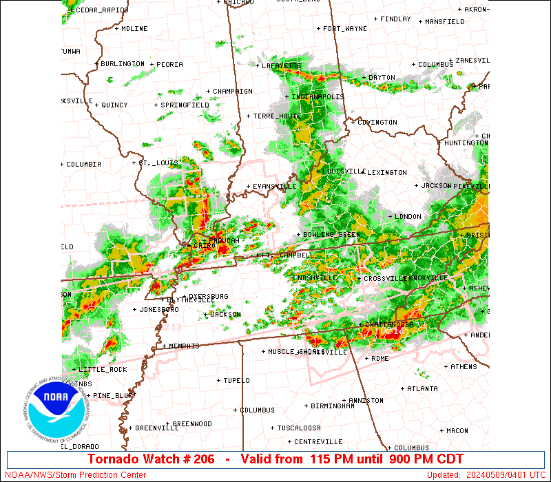
PDS(particularly dangerous situation) tornado watch until 1200 AM CDT


538


 ANOTHER WW IS LIKELY ACROSS MS VALLEY REGION E AND NE OF WW 205.
   
   SVR TSTMS OVER NERN PORTIONS AR IN WW 205 MAY BE MAINTAINED AS THEY
   MOVE NEWD INTO DESTABILIZING AIR MASS OVER THIS REGION.  MAIN
   UNCERTAINTY INVOLVES NRN EXTENT OF FAVORABLE/SFC-BASED EFFECTIVE
   INFLOW...GIVEN ROBUST STRENGTH OF COLD POOL OVER MO OZARKS AND
   LIMITED TIME FOR DESTABILIZATION TO ITS E.  SFC MESOANALYSIS SHOWED
   SRN EDGE OF THAT COLD POOL FROM NEAR FLP NEWD ACROSS CARTER COUNTY
   MO THEN NWD TOWARD SWRN FRINGES STL AREA...E OF WHICH 3-4 MB/2-HOUR
   FALLS ARE FOCUSED ACROSS SERN MO/NERN AR REGION.  THIS TENDENCY IS
   CONSISTENT WITH SFC LOW SHIFT/DEVELOPMENT NEWD INTO REGION...WHILE
   RELATED ISALLOBARIC FORCING WILL MAINTAIN BACKED NEAR-SFC WINDS AND
   ENLARGED LOW-LEVEL HODOGRAPHS FAVORABLE FOR SUPERCELLS/TORNADO
   POTENTIAL.  DEEP-LAYER SHEAR WILL REMAIN SUITABLE ALSO...WITH
   EFFECTIVE SHEAR MAGNITUDES AROUND 45-55 KT.  OUTFLOW BOUNDARY...N OF
   WHICH HODOGRAPHS ARE FURTHER ENLARGED...WAS ANALYZED FROM WRN KY MCS
   SWWD ACROSS MEM AREA THEN NWWD OVER NERN AR.  HOWEVER...SFC DIABATIC
   HEATING IS DESTABILIZING AIR MASS TO ITS N SUCH THAT 500-1500 MLCAPE
   MAY DEVELOP ACROSS SERN MO INTO SRN IL AND WRN KY BEFORE SUNSET. 
   WAA WILL MAINTAIN FAVORABLE BUOYANCY IN PRE-STORM ENVIRONMENT.
_________________________________________________________________________


Good afternoon ladies and gentlemen. This is the first official post of central Kentucky Severe Weather, a collaboration between many weather lovers from this area to bring severe weather, snow, flooding, etc. pictures to you all. Today it has been sunny over a lot of the area, which is really weird. I haven't seen the sun in a while. :) We have a long few days ahead of us, so listen  up.

As I speak, isolated thunderstorms are firing up across the area as sunshine has broken out and temps are high and its REALLY humid. There is a severe thunderstorm watch out for extreme southern KY until 8 PM cdt.


The severe weather threats will likely increase tonight, through Wednesday. The SPC has some of KY in a slight risk for tonight. Mainly areas west of I-75.


We will watch that. Everything looks great for a severe weather and flash flood event tomorrow. SPC has this outlook.


The HPC says this about the flooding rains:


The GFS is showing a boat load of rain falling, and at this point I am in agreeance with it. the NAM seems, for once, too underdone with this.

That is all for now, have a great day, and God bless.